
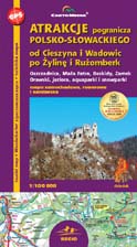
Attractions of polish-slovakian frontier
from Cieszyn and Wadowice to Žilina and Ružomberok
scale
legend
size
1st edition
author
publishers
ISBN
1:100 000
5 languages
97 x 67 cm
2008
Michael Siwicki
978-83-7499-118-6
Beskidy maps
distribution
![]()
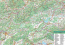
The map is double-sided and shows west part of polish Carpathians and a big part of northern Slovakia, with Liptov and Orava.
That's the map for drivers, as well as bikers and skiers. The legend consists of 90 signs in 5 languages (PL, GB, D, SK, RUS). Vivid colour hills shading clearly shows the relief. Distances in kilometres, time distances on selected tourist routes, mountain bike and rafting routes, as well as ski-lifts and plenty other informations make this map very useful for everyone.
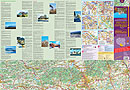
On back side you can find several informations about the ridges, national parks, cities and villages, enriched with photos. There are city-maps of Cieszyn, Bielsko-Biała, Żywiec, Žilina, Ružomberk and Liptovský Mikuláš.
The map is updated every year. It has been made particularly for drivers and other tourist looking for beautiful landscapes and monumental facilities.