
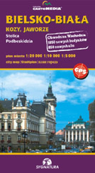
Bielsko-Biała
Kozy and Jaworze, capital of Podbeskidzie
scale
legend
size
1st edition
author
publishers
ISBN
1:20 000
4 languages
97 x 67 cm
2006
Michael Siwicki
978-83-87873-94-3
Beskidy maps
distribution
![]()
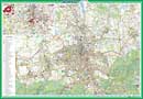
The city-map covers whole Bielsko-Biała, the south part exists in smaller scale. The citry-maps shows whloe Kozy and Jaworze, too.
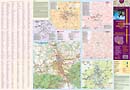
The explanation contains about 90 signs, described in 4 languages (PL, GB, D, RUS).
Buildings are detailed, enhanced of their numbering. Names of bus-stops exist there, bankomats, internet-cafes and more ... . There is geographical net for GPS (WGS-84). City was shown in 1:10 000 scale and an Old Town in 1:5 000 scale.
Back-side is unique. There are 5 maps, so called zones: office, health, cultural, accommodation and communication. There is a map of surroundings, history of the city, monuments as well as index of street names.