
Gorce
Nowy Targ and Rabka-Zdrój
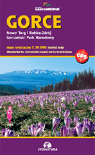
scale
legend
size
1st edition
author
publishers
ISBN
1:50 000
5 languages
82 x 56 cm
2004
Michael Siwicki
83-7499-020-1
Beskidy maps
distribution
![]()
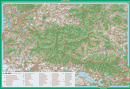
The map covers whole Gorce from Raba Wyżna and Rabka-Zdrój to Krościenko, from Luboń Wielki to Niedzica.
The explanation contains about 90 signs, described in 5 languages (PL, GB, D, F, SK). Vivid hill shading in two colours with 20-m interval countour lines clearly show the relief. There is geographical grid for GPS here, time distances and mountain bike routes, as well as routes for horse-riding and skiing.
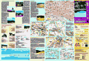
On back side you can find several informations about the region. There are the panoramas here and comprehensive touristic directory. You can find a city-map of Rabka-Zdrój, Mszana Dolna, Nowy Targ and Krościenko too, several informations about national park, coverage of mobile phones.